This guide follows the Confederated Tribes and Bands of the Yakama Nation through a selected historical account, the Nation-hosted 1855 treaty text, language teaching and a 2021 fisheries plan. The named constituent peoples, historical treaty wording and present government are related but different kinds of evidence. Pahto’s modern landscape image provides one specifically identified setting.
See each region’s evidence for historical or present-day scope.
Homeland / region
Pacific Northwest / Washington
Research depth
Source guide
Source collection
6 annotated resources · 6 Indigenous-led
Inspected sources
4 substantive works · selected content reviewed
Initial adequacy
Still unfinished
Source review
October 28, 2026
A source guide for a deeper dive.This entry provides a brief orientation and an organized reading path. A comprehensive deep dive has not yet been completed. Follow the annotated sources and distinguish primary community accounts from outside reference material.
Still unfinished
A bounded actual-content starting path and specifically scoped credited picture are available. Fuller history, source comparison and community review remain open; quantity does not establish completion.
Assessment recorded October 28, 2026. This is separate from research completion and community review.
Compare original treaty records, translation and implementation histories.
Develop individually scoped histories for constituent peoples without deriving identity from map proximity.
Review later programme changes and outcomes separately from the dated 2021–2024 descriptions.
Backdrop photographs & credits
These photographs have individual, documented connections to this entry. Their captions and source records define the people, place, object, and period shown; no one photograph represents every community within a broader label.
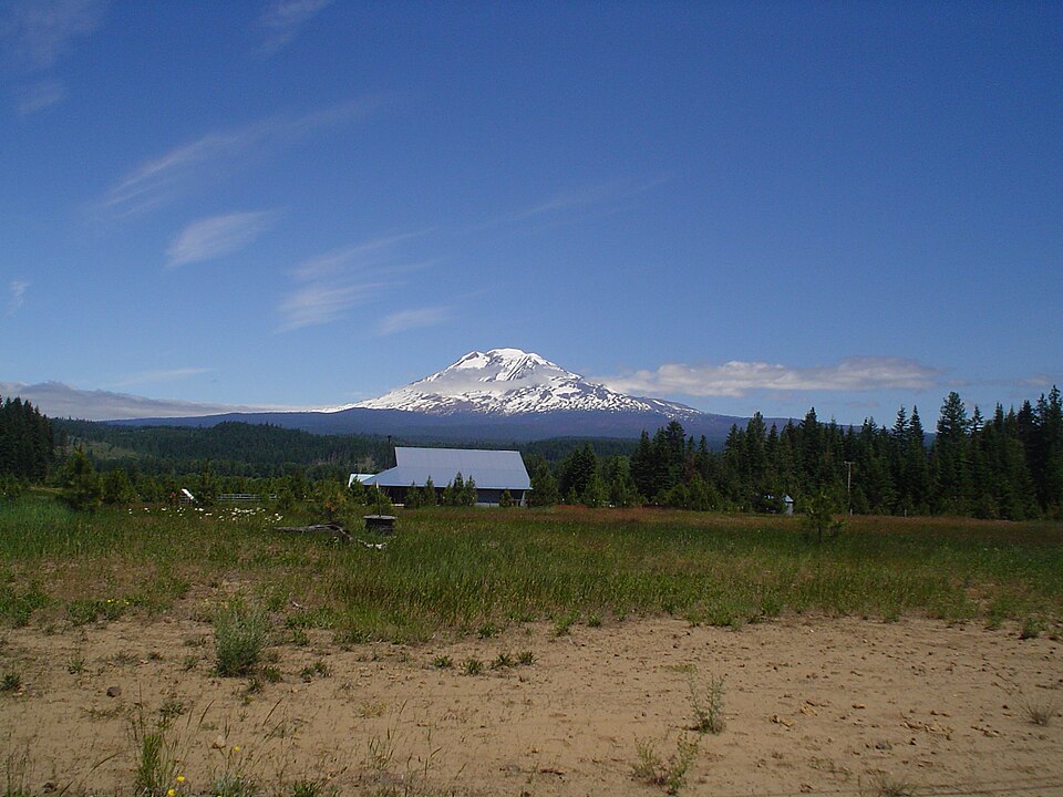
Mount Adams/Pahto viewed from near Trout Lake, 2009 Highwayboy / Wikimedia Commons · Author-released public domain
The photographer identifies the view as from Highway141 north of Trout Lake. The Nation’s historical land account specifically names Pahto/Mount Adams. This is a modern view of one public landscape, not proof that the camera/foreground is on reservation land, a territorial boundary, all constituent peoples or an adopted sacred-symbol interpretation. Complete available retrieved JPEG imported unchanged. Background/card CSS crops and overlays affect presentation; the opened page retains the complete available frame proportionally.
Image, association, and reuse record reviewed 2026-10-28.
Full photographs are displayed proportionally above. A translucent background copy may be cropped by the viewport; it does not replace the complete image or its record.
The visual treatment does not change the research status, evidence, or remaining gaps recorded in this profile.
Start reading here
A short purposeful path through selected actual-content works. Read annotations for community, period and inspection limits; this is not a complete history or community endorsement.
Read a selected introduction to the 2021 fisheries planning framework.
These are selected starting points. The full annotated collection, source perspectives, inspection limits and remaining research questions follow below. A starting guide is not an exhaustive history or community endorsement.
01
Identity and context
The Yakama Nation is a contemporary confederated government with multiple constituent peoples.
Focus the next stage of research on: Nation-published history, treaty context, languages and distinct community histories. The sources below are selected reading paths; their authorship, dates and community scope should guide how they are used.
Land, waterways and seasonal movement in the Nation’s account
The Nation’s history describes winter villages near waterways and movement across lowlands and higher country as foods became available. It names Pahto, also called Mount Adams, within this account. The 2009 photograph is a view from near Trout Lake, not a picture of the whole reservation or a present boundary.
The Nation-hosted treaty text displays separate signing, ratification and proclamation dates. Its preamble names tribes and bands treated together for the document’s purposes. Selected Articles1–3 set out historical cession, reservation and resource provisions. The text alone does not establish consent, implementation or current legal entitlements.
The language programme describes school and community teaching and a teacher-development approach; its dated references should guide further enquiries about what is offered now. The 2021 fisheries plan connects management with language, education and responsibilities to future generations. Its projects and objectives remain that publication’s institutional account, not an independent ecological evaluation.
Compare original treaty records, translation and implementation histories.
Develop individually scoped histories for constituent peoples without deriving identity from map proximity.
Review later programme changes and outcomes separately from the dated 2021–2024 descriptions.
Cohort11: selected actual-content reviews preserve their institutional/community scope. Existing source cards are upgraded at the same ID and URL where noted; repeated publications are not globally new works.
Follow the reading path
Sources & further reading
Open any title to read the original source. Annotations explain what each link can help you explore.
No Indigenous-led source is identified in this entry yet. This is a gap in this collection, and does not imply an absence of community knowledge or organization.
Government homepage retained as an official navigation route; it is not a counted history source. The selected history, treaty text and programme bodies are reviewed separately.
The 2021 plan connects language, teaching and resource relationships with fisheries management, partnerships and restoration priorities. Its planning framework is not a measured account of every later result.
Inspection: Content reviewed for the stated scope
Scope: Actual PDF title/contents and revision line, prefacep5, introduction/managementpp9–10, and Nature and Geographic Scopep25; PDF and printed numbers coincide for these selections. Normal HTTP200 complete file retrieved; only these selected bodies read.
Review recorded: October 28, 2026
Access note: Web reader could not handle the21.9MB PDF, so normal download and text extraction were used. Figures, photographs, map geometry, biological tables, current staff/species totals, legal holdings and the rest of the document were not inspected or reproduced. Source-specific copyright photos remain excluded. Plans/claims are attributed to the 2021 publication, not treated as current ecological outcomes.
A short programme introduction whose central language/stewardship passage overlaps the 2021 plan preface. Retained as institutional context and excluded as another substantive work.
Inspection: Supporting or limited review; see scope
Scope: Actual introductory body, web lines69–71; at-a-glance list encountered but not adopted.
Review recorded: October 28, 2026
Access note: The photo, present numerical totals and linked material were not inspected. The fuller plan receives one count; this overlapping short introduction does not add another.
The Nation’s historical account relates waterways, winter villages and seasonal movement across elevations. Only this bounded portion is used; later flag/war and treaty summaries require separate comparison.
Inspection: Content reviewed for the stated scope
Scope: Actual History of the Yakama Nation’s Land section, web lines41–50; page-end attribution to Carol Craig also encountered.
Review recorded: October 28, 2026
Access note: Population and acreage totals, sacred-symbol interpretation, original images/map, later unattributed flag commentary and disputed compressed treaty chronology are not adopted. No current ownership or ecological-outcome claim.
The reproduced preamble names participating tribes and bands; selected articles set out cession, reservation and fishing/gathering provisions. These are historical textual terms, not proof of implementation or present boundaries.
Inspection: Content reviewed for the stated scope
Scope: Actual displayed dates, preamble and complete Articles1–3, web lines35–49.
Review recorded: October 28, 2026
Access note: Original signed manuscript, translation, negotiations, assent, implementation and later case law not independently inspected. Historical wording is retained at the source, not converted into current legal advice or mapped boundaries.
The programme explains classroom and community routes, a teacher-development model and language competitions. Embedded references to 2022–2024 establish a dated programme account rather than a guaranteed current timetable.
Inspection: Content reviewed for the stated scope
Scope: Actual mission and selected classroom/community, teacher-development and competition explanations, web lines36, 48–113, 126–138.
Review recorded: October 28, 2026
Access note: Linked short URLs, applications, legal certification requirements, vocabulary audio and current schedules were not inspected. Historical cohort numbers and speaker totals are not adopted.
Community history·Language·Contemporary institutions
Continue the research
Suggested reading and supporting references
These collections preserve links from supplied studies and further research leads. The collection notes explain their provenance and review status. Links already used above point to their source cards. Supporting references and unread leads are excluded from the substantive inspected-source count.
Klickitat involvement in the wars of 1855 and 1856 · 13 links
Queued with Yakama for the confederation and regional context. Klickitat, Cascade, Nisqually, and Yakama identities are not interchangeable; a distinct Klickitat access point remains a research task.
Related entries may represent alternate names, constituent communities, wider groupings, or historical connections. Read the naming notes before treating entries as equivalent.
Robey’s Atlas of Indigenous North America · Compiled October 19, 2026 · Yakama