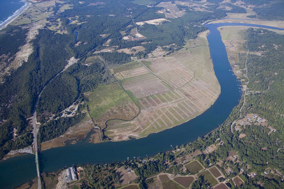
Coquille River mouth and Bandon Marsh, aerial viewRoy W. Lowe / U.S. Fish and Wildlife Service, Pacific Region / Wikimedia Commons — CC BY 2.0; item also records official-duty USFWS public domain
The Coquille Indian Tribe’s accounts connect lower river villages, seasonal relationships and several ancestral language traditions with continuing community life. A third reading explains how restored land and stewardship fit its modern institutional history.
See each region’s evidence for historical or present-day scope.
Homeland / region
Pacific Northwest / Oregon
Research depth
Source guide
Source collection
5 annotated resources · 4 Indigenous-led
Inspected sources
3 substantive works · selected content reviewed
Initial adequacy
Still unfinished
Source review
October 28, 2026
A source guide for a deeper dive.This entry provides a brief orientation and an organized reading path. A comprehensive deep dive has not yet been completed. Follow the annotated sources and distinguish primary community accounts from outside reference material.
Still unfinished
A bounded actual-content starting path and specifically scoped credited picture are available. Fuller history, source comparison and community review remain open; quantity does not establish completion.
Assessment recorded October 28, 2026. This is separate from research completion and community review.
Read archaeology and original treaty/termination/restoration records alongside the Tribe’s narrative.
Expand public Coquille-authored language scholarship without entering member-restricted collections.
Verify current management/access information before practical land-use advice.
River aerial is a dated USFWS regional view, not a traditional-village identification or proof of completed restoration works.
Backdrop photographs & credits
These photographs have individual, documented connections to this entry. Their captions and source records define the people, place, object, and period shown; no one photograph represents every community within a broader label.
Coquille River mouth and Bandon Marsh, aerial view Roy W. Lowe / U.S. Fish and Wildlife Service, Pacific Region / Wikimedia Commons — CC BY 2.0; item also records official-duty USFWS public domain
Dated modern Coquille River-mouth/Bandon Marsh landscape. Named-waterway regional context supported by the Tribe’s account; not an exact village, current boundary or universal Coquille landscape. EXIF describes restoration work/plans, not proof of later completion. Complete available retrieved JPEG imported unchanged. Background/card CSS crops and overlays affect presentation; the opened page retains the complete available frame proportionally.
Image, association, and reuse record reviewed 2026-10-28.
Full photographs are displayed proportionally above. A translucent background copy may be cropped by the viewport; it does not replace the complete image or its record.
The visual treatment does not change the research status, evidence, or remaining gaps recorded in this profile.
Start reading here
A short purposeful path through selected actual-content works. Read annotations for community, period and inspection limits; this is not a complete history or community endorsement.
Read how restored land relates to stewardship and community institutions.
These are selected starting points. The full annotated collection, source perspectives, inspection limits and remaining research questions follow below. A starting guide is not an exhaustive history or community endorsement.
01
Identity and context
The Coquille Indian Tribe has homelands in southwestern Oregon and publishes its own account of history and contemporary community life.
Focus the next stage of research on: Coastal and river homelands, termination and restoration histories, language and contemporary government. Start with the annotated sources and compare each publisher’s scope and perspective.
The Tribe describes permanent villages along tidewaters and lower rivers, including the Coquille River and South Slough, and seasonal movement among resource areas. It cautions that known sites do not mark the complete extent of ancestral homelands. The river-mouth aerial is a modern regional setting, not a boundary map.
The language page places Miluk-speaking and Athabaskan-speaking ancestors within Coquille history and describes multilingual relationships among villages. It also describes efforts to reconnect members with ancestral languages. Those relationships should be read in the Tribe’s own context without reducing language change to the disappearance of a people.
The Tribe’s account connects 1989 restoration with later opportunities to regain land and support community life. Its forest discussion explains stewardship as both a responsibility and a source of institutional support. The page’s numerical economic claims and property-access details require separate current checking.
Read archaeology and original treaty/termination/restoration records alongside the Tribe’s narrative.
Expand public Coquille-authored language scholarship without entering member-restricted collections.
Verify current management/access information before practical land-use advice.
River aerial is a dated USFWS regional view, not a traditional-village identification or proof of completed restoration works.
Cohort11: selected actual-content reviews preserve their institutional/community scope. Existing source cards are upgraded at the same ID and URL where noted; repeated publications are not globally new works.
Follow the reading path
Sources & further reading
Open any title to read the original source. Annotations explain what each link can help you explore.
No Indigenous-led source is identified in this entry yet. This is a gap in this collection, and does not imply an absence of community knowledge or organization.
The Tribe describes permanent riverine villages, seasonal movement and continuing ties despite displacement and termination. It explicitly warns that known sites do not define the full reach of ancestral homelands.
Inspection: Content reviewed for the stated scope
Scope: Complete actual main body read. Synthesis selects village/seasonal-camp paragraphs, uncertainty about homeland extent and Treaties and Termination continuity discussion. Material-use/ceremonial detail not republished.
Review recorded: October 28, 2026
Access note: Actual selected public content read on 2026-10-28 through normalHTTP200, ordinary web reader or stated PDF pages. No access bypass or outreach. Linked originals, recordings, images and full collections were not automatically reviewed or licensed. NormalHTTP200 HTML. Original archaeology, unratified treaties and legal records unreviewed. No numerical land/ancestry/current-territory claims; no present access rights inferred from a historic place.
Community or Indigenous-organization perspective linked for this entry. Use “Coquille Indian Tribe” to begin with the publisher’s own account; check whether its scope is one community or a wider people.
Historical context for this entry. Read “[Coquille vocabulary, map, and census] | Smithsonian Institution” with attention to the author, period covered, and communities named; compare with community-published accounts where available.
The Tribe explains its ancestors’ varied language connections and the work of reconnecting members with those languages. Historical language loss does not imply the disappearance of Coquille people.
Inspection: Content reviewed for the stated scope
Scope: Complete actual public body: Miluk/Hanis and Athabaskan ancestral context, oral-memory attribution, multilingual village relationships and present reconnection statement. Linked library materials not read.
Review recorded: October 28, 2026
Access note: Actual selected public content read on 2026-10-28 through normalHTTP200, ordinary web reader or stated PDF pages. No access bypass or outreach. Linked originals, recordings, images and full collections were not automatically reviewed or licensed. NormalHTTP200 HTML. Broad linguistic-family labels are presented as the Tribe’s page description, not independent proof of disputed classifications. No recordings, underlying interviews or current fluency/outcomes inspected.
The Tribe links regained land and stewardship with restoration and community services. Different land areas have different purposes and access conditions; a historical connection is not a visitor-access entitlement.
Inspection: Content reviewed for the stated scope
Scope: Complete actual main body read; synthesis selects 1989 restoration introduction, Coquille Tribal Forest account and stewardship/community-support rationale. Other named properties and public-access distinctions read for context only.
Review recorded: October 28, 2026
Access note: Actual selected public content read on 2026-10-28 through normalHTTP200, ordinary web reader or stated PDF pages. No access bypass or outreach. Linked originals, recordings, images and full collections were not automatically reviewed or licensed. Undated page. Acreage, harvest/jobs figures, certification and present access rules are not independently verified or used as current advice. Linked management plans and original land legislation uninspected.
Related entries may represent alternate names, constituent communities, wider groupings, or historical connections. Read the naming notes before treating entries as equivalent.
Robey’s Atlas of Indigenous North America · Compiled October 19, 2026 · Coquille